The State of Eritrea
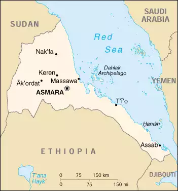
Eritrea, officially the The State of Eritrea, is a country in Africa, with an area of 117,600 square kilometers and a population of around 6,081,196. Its gdp is $2,065.00 Millions(2011). The capital of Eritrea is Asmara, and the official currency is Eritrean nakfa(ERN). Its neighboring countries are Djibouti, Ethiopia, Sudan.
Country Name:
The State of Eritrea
Flag:
Capital:
Coordinate:
15°20′N 38°55′E
GDP(Millions):
$2,065.00 Millions(2011)
Population:
6,081,196
Area:
117,600 km2 (45,406 sq mi)
Currency:
Language:
Trigrinya, Arabic, English, Tigre, Kunama, Afar, other Cushitic languages
Power Station:
ISO:
ER,ERI
Calling Code:
TLC:
.er
Drivingside:
right
Timezone:
Climate:
Hot, dry desert strip along Red Sea coast; cooler and wetter in the central highlands (up to 61 cm of rainfall annually, heaviest June to September); semiarid in western hills and lowlands
Electricity:
230 V / 50 Hz / plug type(s): C, L
Power Station:
Sunni Muslim, Coptic Christian, Roman Catholic, Protestant
Religions: